GNS530W (GNS-530W)


- For Sale
- GPS
- GARMIN GNS530W (GNS-530W)
- Yes
- South Windsor, CT USA
$8,995 USD
- For Sale
- GPS
- GARMIN GNS530W (GNS-530W)
- Yes
- South Windsor, CT USA

General Specs (cont.)
011-01064-40
011-01064-00
1
Repaired
Detailed Description
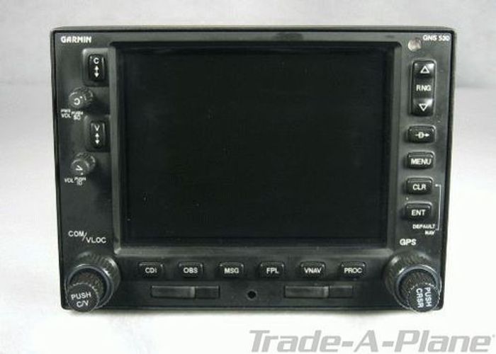
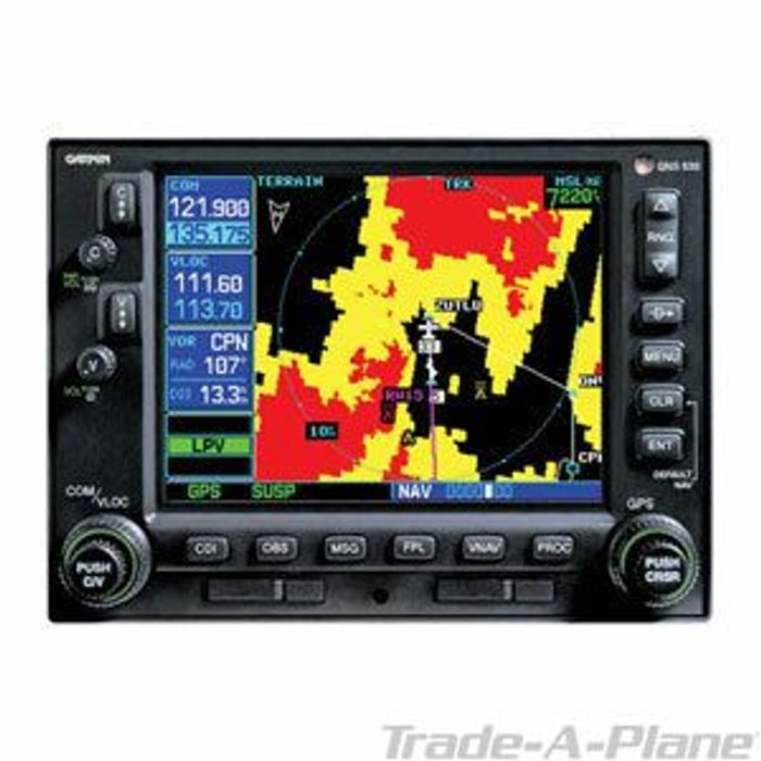
The GNS-530W is the larger version of the GNS-430W. The most obvious difference between the two is the GNS-530W's larger display (320 x 234 pixels versus 240 x 128 pixels in the GNS-430W). The GNS-530W may also function as a display for compatible with Class B TAWS Terrain Systems. Beyond these differences, the GNS-530W shares the GNS-430W's advances, particularly WAAS Approach Capability and Terrain Information.

WAAS Approach Capability - WAAS, or Wide Area Augmentation System, is a fundamental improvement to GPS accuracy. By adding a series of ground stations and geostationary satellites, WAAS GPS is typically 5 times more accurate than "regular" GPS. This means that it is now possible to fly a complete "Virtual Glideslope" approach into an airport with no local ground-based navigation aids whatsoever. A GNS-530W makes the following approaches available:

    LNAV (Lateral Navigation): This is a new name for non-precision GPS approaches as we have known them. Like all non-precision approaches, this has a minimum descent altitude (MDA), based on obstructions and terrain.

    LNAV/VNAV (Lateral Navigation / Vertical Navigation): This class of approach provides Glideslope vertical guidance with a decision altitude (DA) typically 350 feet AGL.

    LPV (Localizer Performance with Vertical guidance): This is the most precise of the WAAS GPS approaches, the GPS equivalent of a Cat I ILS approach. It also offers Glideslope vertical guidance, but the DA is lower, typically from 200-250 feet AGL.

There are thousands of FAA-approved LPV WAAS approaches, with more being added regularly. The FAA's stated goal is to have a WAAS approach available for every public runway at least 3,200 feet long. To see if the airports you use offer WAAS capability, please click here for the FAA's information about GPS/WAAS Approaches.

Terrain Information - With the GNS-530W, the terrain database is standard (for improved awareness and safety), and it provides this information with greater resolution and precision than the GNS-530. It is possible to add terrain information to a GNS-530, but this is an expensive option.

Other GNS-530W improvements over the GNS-530 include:

    Faster position calculations and screen updates (5x per second)
    Improved annunciation
    Holding patterns
    Autopilot roll steering
    Parallel track calculation
    Dead reckoning (This is a backup if GPS signal is lost)
    More informative status pages
    Better, faster communication between dual GNS-530W / GNS-530W installations
    Configuration for GDL-69 / GDL-69A XM Receivers (if installed)
    Simplified installation paperwork

The GNS-530W may be used with any of these Indicators (the Garmin units are the official choices):

    Garmin GI-106A GPS/VOR/LOC/Glideslope Indicator
    Garmin GI-106B GPS/VOR/LOC/Glideslope Indicator
    Mid-Continent MD200-306 GPS/VOR/LOC/Glideslope Indicator
    Mid-Continent MD200-706 GPS/VOR/LOC/Glideslope Indicator
    Collins IND-351A GPS/VOR/LOC/Glideslope Indicator
    King KI-206 GPS/VOR/LOC/Glideslope Indicator
    King KI-209A GPS/VOR/LOC/Glideslope Indicator
    King KNI-520 GPS/VOR/LOC/Glideslope Indicator
    King KI-525/525A HSI (part of a KCS-55/55A system)